
This action alert is adapted with permission from an action alert originally developed by Sustainable Mobility for Arlington County (SusMo).
As Arlington County approaches the end of its years-long Arlington’s Transportation Future effort to overhaul its Master Transportation Plan, advocates have one final chance to share feedback on the draft plan – comments are due Sunday, August 23rd.
Our overall take: the draft Multimodal Transportation Plan is really good! The curb-space hierarchy prioritizes safety and building out the bike and transit networks over parking(!); it recognizes the need for enforcement and prioritizes enforcement efforts on those laws that have the greatest safety impact; it supports EV charging not just for cars, but e-bikes and e-scooters as well. All in all, County staff stayed true to the goal of thoroughly re-envisioning mobility to be people-focused.
Our primary goal is ensuring that the boldest elements of the plan aren’t watered down before final passage. We want staff to see that this new vision for mobility has broad support among the community. That being said, we do have a few nits to pick, outlined in detail below, that we think are worth calling out amidst overall praise for the plan. For a question-by-question guide to the survey, see the Detailed Suggested Feedback section further below.
Safe Accommodations During Construction
A lack of safe accommodations for people walking, biking, and scooting through construction zones has been a long-standing issue in Arlington. While there are policies and strategies addressing this (see page 44 of the draft plan), they aren’t sufficiently actionable and clear. There is nothing in the draft strategies that would necessarily be inconsistent with one of the most egregious construction failures we’ve recently seen – when work was being done on Hayes St at the intersection with Fern Street, the sidewalk was closed and pedestrians detoured into the protected bike lane, the protected bike lane was closed with no reasonable detour given, and FOUR lanes of car traffic remained open (two in each direction). We need a clear policy that temporary facilities must match the safety, convenience, and functionality of the original sidewalk or bike facility and that full facility closure and detouring on the other side of the street or on a different street is only permitted when alternatives are completely unfeasible.
Missing Links in the Micromobility Network
We also think there are some important links missing in the Micromobility Network. This is what the County will be building toward over the next 30 years, so it is important to get it right. Examples include:
- Eads St/Route 1 Barrier Between Four Mile Run & 23rd St. The micromobility network map doesn’t show any way to travel east-west across Eads Street & Route 1 between the Four Mile Run Trail and 23rd St S. There is an existing narrow sidewalk that connects Fort Scott Drive to 27th St S using the crosswalk across Eads at Fort Scott Drive and the traffic signal on Route 1 at 27th St S, but it is too narrow to be safely shared and the sidewalk on Route 1 between the crosswalk and the pedestrian link is dangerously narrow. This should be called out as an important micromobility link on the network map and the county should work to acquire the necessary land to widen and improve this link.
- West-Side Glebe Rd Alternative in Ballston. Micromobility is only the 3rd priority on Glebe Rd after Pedestrians and Transit, is only a priority in the core of Ballston, and the County has previously released a study declaring protected bike lanes on Glebe infeasible. That makes it critically important to have parallel routes for micromobility users as alternatives to Glebe. The draft micromobility network shows useful parallel links on the west side of Glebe north of Fairfax Dr and south of S Carlin Springs Rd, but leaves a gap between Fairfax and Carlin Springs. This gap should be filled. The under-construction Ballston Holiday Inn redevelopment is building a new trail connecting Fairfax Drive to North Wakefield Street. That new trail (in addition to micromobility priority on Wakefield), across Wilson Blvd at the existing light, turning east onto 7th St S and then south down Vermont St to Carlin Springs Rd would allow micromobility users to navigate this portion of Ballston without waiting for potential facilities on Glebe.
- Access for Upper Green Valley. The northern portion of Green Valley (north of Glebe Rd) remains largely cut-off from the Micromobility Network under the draft plan. To the east is the largely impenetrable Army-Navy Country Club; to the south is Glebe Rd which is not in the Micromibility Network, nor are any micromobility links shown across it; to the west is more Glebe Rd, and a tiny stretch of Walter Reed Drive, which may get micromobility facilities from its “priority three” status in the future, but providing safe access for micromobility users to Green Valley at 17th St S would be tricky, especially for southbound travelers, due to the proximity to the Glebe Rd intersection; and to the north a disconnect between 16th St and 17th St S, penetrable only via a narrow, scary sidewalk in the vicinity of Edgewood Street. We think that the existing sidewalk between 16th St and 17th St S should be shown as a priority link on the micromobility network and that the County should seek the land needed to widen it to a safe, shared facility to provide access to this neighborhood.
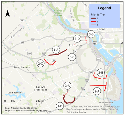
These comments on the Micromobility Network Map echo sentiments explored in detail in our recently-published blog post Focusing Investments in Arlington’s Cycling Network by graduate student researcher Reid Unison. Namely, that investments to upgrade existing but subpar bicycling routes would be especially effective in connecting more Arlingtonians to key destinations and thus encouraging more trips via active modes. Reid’s analysis highlights 9 priority routes for improvement and we believe that those upgrades, in addition to targeted gap-filling, should be the County’s top priority once the plan moves forward to towards implementation.
Detailed Suggested Feedback
| 1. What is your overall impression of the draft transportation plan? Very Positive 2. How well does the draft plan reflect the Vision and Goals identified by the community? Very Well 3. What is the most important feedback you would like the project team to consider as we refine the draft plan? The Strategies regarding safe accommodations during construction for Policy L must be stronger. The status quo is terrible; pedestrians and micromobility users are regularly left with no safe or direct detour while multiple lanes for cars remain open in each direction. I don’t see anything in the draft strategies that clearly goes beyond what the county already does. The Maintenance of Travel plans being issued are not good enough, and they are rarely being enforced in a meaningful way. Both issues must be addressed. 4. How satisfied or dissatisfied are you with the draft policies and strategies overall? Very Satisfied 5. How do you think the draft policies and strategies will impact the future of transportation in our community? Very Positively 6. What is the most important feedback you would like the project team to consider as we refine the draft policies and strategies? The Strategies regarding safe accommodations during construction for Policy L must be stronger. The status quo is terrible; pedestrians and micromobility users are regularly left with no safe or direct detour while multiple lanes for cars remain open in each direction. I don’t see anything in the draft strategies that clearly goes beyond what the county already does. The Maintenance of Travel plans being issued are not good enough, and they are rarely being enforced in a meaningful way. Both issues must be addressed. 7. How do you think the draft Modal Priority Networks will affect your travel in the future? Very Positively 8. What is the most important feedback you would like the project team to consider as we refine the draft Modal Priority Networks? The following micromobility network links: A. We need to improve the existing sidewalk connection between Fort Scott Dr & 27th St for pedestrians and micromobility users. Show this link on the micromobility network map and work to widen it. Otherwise, we have no reasonable place for micromobility users to cross Eads & Route 1 between 23rd St & the Four Mile Run Trail. B. The micromobility network should show the trail connection between Fairfax Drive and N Wakefield St being delivered by the Ballston Holiday Inn Siteplan, and then continue a priority #1 micromobility connection down Wakefield, crossing Wilson, turning east along 7th St N, south along N Vermont St to Carlin Springs Road. This would create a continuous bike alternative to Glebe, filling the gap in the draft network between Fairfax Drive and Carlin Springs Road. C. The micromobility network map should show the sidewalk connection extending Edgewood St between 16th St S and 17th St S, and the County should work to expand it to an appropriate width to work as a facility shared between pedestrians and micromobility users. This appears to be the only reasonable connection into Northern Green Valley, a neighborhood that is otherwise cut off from the micromobility network by Glebe Road and the Country Club. 9. How do you think the draft Street Typology will affect your travel experience in the future? Positively 10. What is the most important feedback you would like the project team to consider as we refine the draft Street Typology? They’re good. Leave them be! 11. How do you think the draft Curb Lane Hierarchy aligns with the plan’s Vision and Goals? Very Well 13. What is the most important feedback you would like the project team to consider as we refine the draft Curb Lane Hierarchy? The draft is great! Keep it as-is! |