How to bike during SafeTrack

Resources for each SafeTrack Surge:
Braddock Road to Huntington & Van Dorn Street try it by bike
King St. to Van Dorn Street try it by bike
King St. to Huntington try it by bike
Greenbelt to College Park try it by bike
New Carrollton to Minnesota Ave. try it by bike
Past surges view
East Falls Church to Ballston
The Orange and Silver lines will be single-tracking between the East Falls Church and Ballston Metrorail stations from Saturday, June 4th to Thursday, June 16th. With a lovely and robust trail network that parallels the Metro corridor, riding your bike to Ballston should be a breeze. Here is WMATA’s page for this surge. Signage BikeArlington has signed a low-stress route from East Falls Church to Rosslyn. Follow the signs that look like this: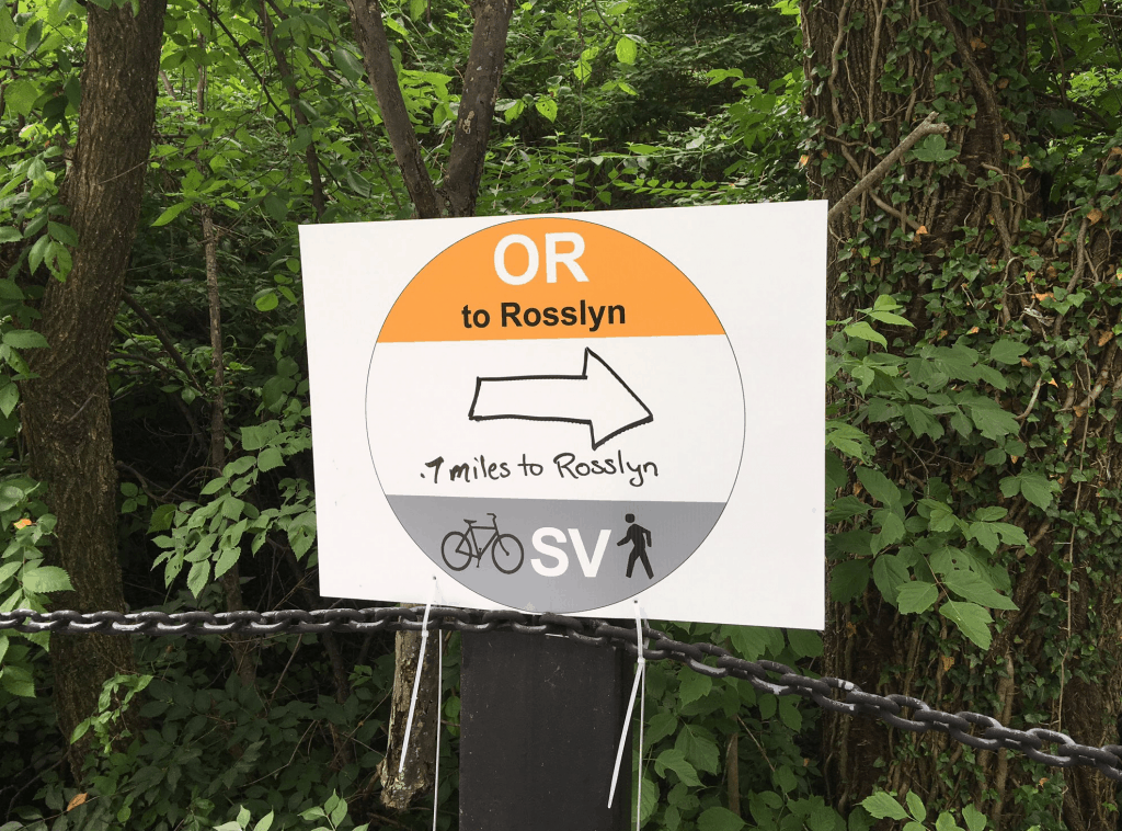 Please note: There will not be any bike train/convoys during the week of June 13th.
Existing biking accommodations
Steps from the entrance to the East Falls Church Metrorail station is one of the region’s best off-street bike trails: The Washington and Old Dominion Trail. Thanks to Northern Virginia’s extensive bike trail network, from there you can ride a bike completely off-street and free from cars all the way into downtown Washington, DC.
Accommodations during this surge
Arlington County’s bike program Bike Arlington has been hard at work getting ready for the surge. You can check out their site here.
Please note: There will not be any bike train/convoys during the week of June 13th.
Existing biking accommodations
Steps from the entrance to the East Falls Church Metrorail station is one of the region’s best off-street bike trails: The Washington and Old Dominion Trail. Thanks to Northern Virginia’s extensive bike trail network, from there you can ride a bike completely off-street and free from cars all the way into downtown Washington, DC.
Accommodations during this surge
Arlington County’s bike program Bike Arlington has been hard at work getting ready for the surge. You can check out their site here.
- Installing a Capital Bikeshare station at the East Falls Church Metrorail station, and adding capacity to Bikeshare stations at the Ballston and Rosslyn Metrorail stations.
- Adding bike racks at the Ballston Metrorail station.
- Improving directional signs along bike commuter routes.
- Providing ambassadors at Ballston Metrorail station to answer questions and offer transportation option information.
Eastern Market to Minnesota Avenue & Benning Road
Arlington Cemetery to Rosslyn try it by bike
The Orange, Blue and Silver lines will be shut down between the Eastern Market and Minnesota Avenue (on the Orange line) and Benning Road (on the Blue/Silver line) Metrorail stations from Saturday, June 18th to Sunday, July 3rd.
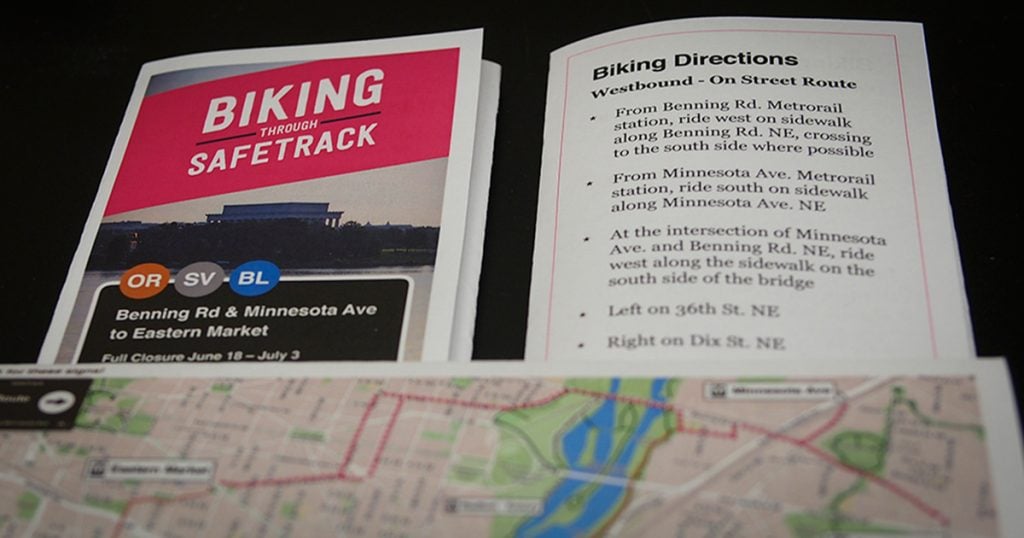
The Blue line will also be shut down between Arlington Cemetery and Rosslyn from Saturday, June 18th to Sunday, July 3rd. Here is WMATA’s page for this surge. Routes & Signage WABA and WMATA have put up directional signs for both an on-street bike route and an off-street bike route connecting the Benning Road, Minnesota Avenue, and Eastern Market Metrorail stations. Here is the map: And the signs look like this: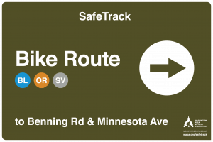 We also have printable maps that include turn by turn directions. Tape it to your handlebars and go!
 In Arlington, the Orange/Silver line will be affected by this surge, and we recommend the route below for anyone interested in biking:
Click here for a printable map.
Ride with us
In Arlington, the Orange/Silver line will be affected by this surge, and we recommend the route below for anyone interested in biking:
Click here for a printable map.
Ride with us
Join a group ride led by folks who know the route. We’ll ride at a speed comfortable for beginners and make sure that your commute is the best part of your day. Convoys are FREE to join and there’s no need to register. Just show up with a bike and helmet! Riders will be asked to sign waivers.
In the mornings: Every weekday during the surge, at 7:45 AM, a bike convoy will depart from the Benning Road and Minnesota Avenue Metrorail stations, heading to the Eastern Market Metrorail station, following our routes. From Eastern Market, the convoy leaders will give riders options for continuing downtown. In the afternoons: Every weekday during the surge, at 5:30 PM, a bike convoy will depart from the Eastern Market Metrorail station, heading to the Benning Road and Minnesota Avenue Metrorail stations, following our routes. Existing biking accommodations There are bike lanes throughout Capitol Hill in the neighborhoods around the Eastern Market, Potomac Avenue, and Stadium-Armory Metrorail stations. Additionally, there is a fantastic multi-use path on both sides of the Anacostia River: The Anacostia Riverwalk Trail. Utilizing these amenities, it’s possible to bike very effectively across nearly all of the region affected by this surge. Unfortunately, however, east of the Anacostia, those accommodations largely end. There are some signed bicycle routes on-street, but for much of Benning Rd. NE and Minnesota Ave. NE, the best place for novice cyclists to be is the sidewalk. When riding on the sidewalk, go slowly, be courteous to pedestrians, and be prepared to get off of your bike and walk. Also be on extra alert for turning drivers. WABA is working to improve bike facilities in the communities across the Anacostia River, and we’d love your support. To get involved, check out our advocacy resources here. If you’re a visual learner, here’s a great video of both the on street and off street routes: Capital Bikeshare Bikeshare will have corrals (which means you’re guaranteed a place to dock) at the following staffed stations:- 17th St & K St NW in Farragut Square, Ongoing 8am to 12pm
- 21st St & I St NW, Ongoing 8am to 12pm
- 13th St & New York Ave NW, Ongoing 8am to 12pm
- Eastern Market, Weekdays 8am-12pm, 6/18 – 6/25 from 4pm to 7pm
National Airport to Braddock Road try it by bike
The Yellow and Blue lines will be shut down between the National Airport and Braddock Road Metrorail stations from Tuesday, July 5th (starting at 8:00 PM) to Monday, July 11th.
Here is WMATA’s page for this surge.
Routes & Signage The City of Alexandria has set up signs directing bicyclists between the closed Metrorail stations. Here is the map: Ride with us Alexandria will also be setting up and leading “bike trains” during the AM commute for this surge. Here is the City’s “Biking during SafeTrack” page. And below is their info on the bike trains:A Bike Train is a group of commuters riding a predetermined route together, making stops along the way on a regular schedule, similar to a bus line. Volunteers from the Alexandria Bicycle and Pedestrian Advisory Committee will be leading bike trains between the Braddock Road, Crystal City, and Pentagon City Metro Stations during the weekday morning commute during Surges #3 and #4. Simply show up with your bike, or Capital Bikeshare, to any of the affected Metro Stations and be ready to ride at the time listed on the schedule below. The total trip time is less than 30 minutes for most cyclists, and is a great way to conveniently complete your trip or get around the surge shutdowns. You don’t need to know the route, as you’ll be escorted by volunteers!


NOTE 1: All departure times are for weekdays between July 6 and July 18th.
NOTE 2: By participating in the bike train, riders all participants in the bike train should realize acknowledge that there are inherent dangers whenever one engages in physical activity. Participants therefore accept all responsibility and assume the risk of injury or damage that may arise, whether directly or indirectly, as a result of bicycle riding. Participants thereby release and hold harmless the City of Alexandria, its employees, agents and representatives, from any liability whatsoever related to participating in the bike train.
Northbound Bike Train: Braddock Road – Crystal City – Pentagon City
A low-stress and flat route from the Braddock Road Metrorail Station to Crystal City and Pentagon City via the Potomac Yard Trail and on-street bike lanes.
Southbound Bike Train: Pentagon City – Crystal City – Braddock Road
A low-stress and flat route from the Pentagon City and Crystal City Metrorail Stations to Braddock Road via on-street bike lanes and the Potomac Yard Trail.
For more information on biking in Alexandria during SafeTrack, including the bike trains, please contact Ray Hayhurst, Complete Streets Coordinator, at raymond.hayhurst@alexandriava.gov. Existing biking accommodations The areas affected by this shutdown are luckily served by some of the best trails in the region. The Mount Vernon trail runs north-south along the Potomac River, and is accessible from the Braddock Road Metro by riding due east on Madison St. After crossing N. Fairfax St., the trail access will be on the left. You can view the trail here on traillink (free registration required) Alternatively, bicyclists can utilize the newest trail in the region, the Potomac Yard Trail. This trail begins behind the Braddock Rd. Metrorail station, on E Braddock Rd. From there, you can ride north to connect with the Four Mile Run trail (which will then take you to the Mount Vernon trail) or follow the posted SafeTrack bike route signs to the Pentagon City Metrorail station.Pentagon City to National Airport try it by bike
The Yellow and Blue lines will be shut down between the Pentagon City and National Airport Metrorail stations from Tuesday, July 12th to Monday, July 18th.
Here is WMATA’s page for this surge. Routes & Signage The City of Alexandria has set up signs directing bicyclists between the closed Metrorail stations. Here is the map: Ride with us Alexandria has decided not to run “bike trains” during this surge. Here is the City’s “Biking during SafeTrack” page. For more information on biking in Alexandria during SafeTrack, please contact Ray Hayhurst, Complete Streets Coordinator, at raymond.hayhurst@alexandriava.gov. Existing biking accommodations The areas affected by this shutdown are luckily served by some of the best trails in the region. The Mount Vernon trail runs north-south along the Potomac River, and is accessible from the Braddock Road Metro by riding due east on Madison St. After crossing N. Fairfax St., the trail access will be on the left. You can view the trail here on traillink (free registration required) Alternatively, bicyclists can utilize the newest trail in the region, the Potomac Yard Trail. This trail begins behind the Braddock Rd. Metrorail station, on E Braddock Rd. From there, you can ride north to connect with the Four Mile Run trail (which will then take you to the Mount Vernon trail) or follow the posted SafeTrack bike route signs to the Pentagon City Metrorail station.East Falls Church to Ballston (July)
The Orange and Silver lines will be single-tracking between the East Falls Church and Ballston Metrorail stations from Wednesday, July 20th to Sunday, July 31st. With a lovely and robust trail network that parallels the Metro corridor, riding your bike to Ballston (and beyond) should be a breeze. Here is WMATA’s page for this surge. Signage BikeArlington has signed a low-stress route from East Falls Church to Rosslyn. Follow the signs that look like this:
Please note: There will not be any bike train/convoys during this surge.
Existing biking accommodations
Steps from the entrance to the East Falls Church Metrorail station is one of the region’s best off-street bike trails: The Washington and Old Dominion Trail. Thanks to Northern Virginia’s extensive bike trail network, from there you can ride a bike completely off-street and free from cars all the way into downtown Washington, DC.
Accommodations during this surge
Arlington County’s bike program Bike Arlington has been hard at work getting ready for the surge. You can check out their site here.
- Installing a Capital Bikeshare station at the East Falls Church Metrorail station, and adding capacity to Bikeshare stations at the Ballston and Rosslyn Metrorail stations.
- Adding bike racks at the Ballston Metrorail station.
- Improving directional signs along bike commuter routes.
- Providing ambassadors at Ballston Metrorail station to answer questions and offer transportation option information.
Takoma to Silver Spring try it by bike
Here’s a map of the route.
The Mongomery County Department of Transportation will also be installing temporary signage along the route.Shady Grove to Twinbrook try it by bike
Franconia-Springfield to Van Dorn Street try it by bike
- During weekdays, the Blue and Yellow lines will be single-tracking.
- During weekends (including Labor Day weekend), the Blue and Yellow lines will be shut down.
Vienna to West Falls Church try it by bike
Fort Totten to NoMa try it by bike
- Ride to the West Hyattsville Green/Yellow Line station.
- Look for MCDOT’s bike route “SafeTrack Detour” signs that begin at station entrances at the Takoma, Silver Spring, Forest Glen, Wheaton and Glenmont stations.
- Route distances along the Sligo Creek Trail, with local street connections, range from about five miles between Takoma and West Hyattsville to 11.6 miles between Glenmont and West Hyattsville.
- As with any bike route, prepare for the weather and be sure your bike has a headlight.

MBT sign image courtesy of 2mstreet.com
East Falls Church West Falls Church (November) try it by bike
Rosslyn to Pentagon try it by bike
What’s WABA Doing?
1. Pushing local transportation officials to create space and infrastructure for biking during the surges. 2. Steering our existing programs and resources to help and support people impacted by SafeTrack. 3. Leading the bike community to help by providing resources, organizing convoys, connecting bike buddies, and encouraging and thanking everyone who bikes! For press inquiries, please contact Colin Browne.Already a Bike Commuter? Help your neighbors and your coworkers!
SafeTrack is huge, affecting nearly our entire region, and we need your help to make sure that nobody on a bike is left behind. How can you help?- Tell us what you’re doing to help people bike during SafeTrack.
- Post about it on our Facebook wall.
- Don’t be smug. People inconvenienced or angry about SafeTrack need our help, not our self-satisfaction.
- Volunteer with us by filling out this form! We need convoy leaders, bike train station attendants, sign installers, flier folders and distributors, and more!
- Be a Bike Buddy!
New to Bike Commuting?
Join us at a City Cycling class! This class is the right fit for you and will give you three things you can’t get anywhere else:- A safe and supportive environment to practice riding and build confidence
- Access to the best bike teachers in the region to answer all your questions
- Riding techniques, tips and tricks to help you get the most out of your ride
You must be logged in to post a comment.